|
 Urban
Sprawl Urban
Sprawl
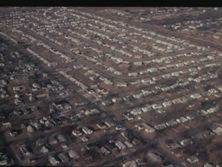
Urban sprawl, or the haphazard spread of urban
development, is a serious issue that has drastically changed
Indiana’s landscape. Sprawl is specifically the spread
of development in an unorganized manner. Inefficient distribution
of land and failure to reduce space between and around developments
leads to fragmentation of the habitats that are left after
the development.
Sprawl is a major cause of habitat and wetland
destruction in Indiana. It has been a continuous problem since
the late 1800s, when industrialization and exponential population
increases expanded the borders of Indiana's cities. In the
twentieth century, the problem grew worse when city-dwellers
began to move from urban to rural areas. In housing patterns
of recent years, even greater responsibility for sprawl has
fallen upon the commuter who wants his or her own five-acre
haven in the country.
In order to support the number of people moving
from the city to the country, Indiana farm fields have been
transformed into housing developments, schools, and shopping
centers. Forests have been further fragmented
as 5,000-square-foot homes have been built in the middle of
"unused" woods. One result of the sprawl is that
Hoosiers, like other Americans, have become utterly dependent
upon the automobile to reach their destinations. Traffic has
increased, and with the added time spent behind the wheel
has come an increase in air pollution.
Another result of sprawl is the destruction
of wetlands. Over eighty-five percent of wetlands in Indiana
have been drained or filled in order to be used for other
purposes, including housing and commercial development in
suburban and rural areas. Wetland loss, in turn, increases
water pollution, since
wetlands can remove up to ninety percent of the pollutants
in water.
While urban sprawl is an issue all over the state
of Indiana, it's a particularly important topic in the northwest
and east central regions.
Statistics from Lake County, along Lake Michigan, show that
during 1990s, 18,000 new housing units were created, while
11,000 were vacant or demolished. Muncie, seventy miles northeast
of Indianapolis, was listed as the “tenth most likely
city in the United States to shrink and sprawl” (“Sprawl”).
Muncie's population is decreasing, but more surrounding land
is being used for new developments.
The Sierra Club lists several solutions for curbing
urban sprawl. For example, people could buy development rights
for land that is in the pathway of sprawl. Other solutions
include more public transportation, fewer new roads, more
compact developments, and the rebuilding of the inner city.
When focus turns from the suburbs and toward the inner city,
growth can happen without the pollution and landscape destruction
that come with sprawl.
Sources:
"Dunelands Group Conservation
Issues." Hoosier Chapter. 2002. Hoosier Chapter
Sierra Club. 16 Oct. 2002. <http://indiana.sierraclub.org/Dunelands/
issues.asp#sprawl>.
"Sprawl." BioMuncie.
2002. 16 Oct. 2002. <http://www.biomuncie.org/Sprawl.htm>.
"Stop Sprawl: Sprawl FactSheet."
Sierra Club. 2002. Sierra Club. 16 Oct. 2002. <http://www.sierraclub.org/sprawl/factsheet.asp>.
|